|
|
|
Location and Background
The Cluster Property is located 30km north of Wenchi in the Brong Ahafo region of Ghana. Cluster is a successor Prospecting License from the regional Bui Reconnaissance License. Its name derives from its multiple gold-anomalous prospects (namely Awisa, Chert Ridge, Brumo, Kwakasiem and Muramurra Prospects).
Geology and Mineralisation
The Property is situated in a Lower Birimian sequence of isoclinally-folded phyllites, wackes and volcaniclastics, with the occasional volcanic unit. Structural corridors exhibiting multiple reactivation and alteration have exploited the collective rheological contrasts between lithological sequences. These corridors have undergone intense silicification which now manifest as extensive, elongated "chert"-like lenses with noticeable and associated positive relief. The crustal-scale corridors have channelled and focused auriferous fluids and as they are zones of crustal weakness they have been exploited by felsic intrusives.
All mineralisation is structurally controlled and is associated with intense silica and carbonate alteration and associated sulphide (pyrite and arsenopyrite).
Exploration Strategy
The aim is to develop the Chert Ridge drill prospect and the other anomalous areas into measured resources. Work achieved to date has included:
- Airborne geophysical, landsat, aerial photo interpretations combined with groundtruthing defined a prospective regional structure.
- Regional stream sediment sampling defined anomalous drainages from this structure.
- Four areas were investigated geochemically with reconnaissance soil-sampling using soil net technology (300m x 300m grid). Four areas received detailed soil gridding (200/500m x 50/25m). This work has delineated a number of drill targets.
- Trenching has revealed the structural-stratigraphic setting at one of the drill targets (Chert Ridge).
- Geological and regolith mapping defined the geological setting of the gold-in-soil anomalies and facilitated the development of a likely mineralization model.
- An Induced Polarisation (I.P.) survey at Chert Ridge.
- A number of phases of RC and DD scout drilling have been conducted at the Chert Ridge Prospect which have progressively defined an open-ended and continuous gold-mineralized structure exceeding 2,200 meters in strike. Two potentially economic shallow-plunging high-grade zones with a cumulative strike of 720m have been defined within this overall strike.
- The objective now is to extend the mineralized structure within the 16km-long portion of the Chert Ridge geophysical trend that is under license and to follow the shoots down plunge and to identify additional high-grade zones of mineralisation.
- In the near- to medium-term, Birim needs to investigate and potentially develop the Awisa, Brumo and Kwakasiem Prospects to the same level as the Chert Ridge Prospect.
|
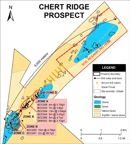 |
Chert Ridge Target
Location and Background
The Chert Ridge Prospect is located in a narrow extension of the northern boundary of the Cluster Property. This area is located 40km north of Wenchi and just west of the main Wenchi-Bole road to northern Ghana.
Santa Fé Inc. defined this target using soil sampling, trenching and 6 RC holes in 1996. Only one of the holes intercepted the zone and produced 6m @ 2.2g/t Au. Volta has progressively refined and developed the understanding of this zone which has distinct potential to develop into a considerable resource at a centralised position amidst numerous other encouraging anomalous zones (Mo West Prospect 4km; Tombe Prospect 6km; Kwakasiem 7km; Brumo 7km; Chenchu Mountain 20km away).
Geology and Mineralization
The contact between a sequence of phyllites and volcaniclastics (with volcanics) has provided sufficient rheological contrast to focus a zone of shearing and reactivation. This zone exhibits strong silica and carbonate alteration and has accommodated at least one phase of felsic intrusion. The I.P. data reveals a number of chargeable and resistive axes that trend oblique to, and intersect with the Chert Ridge Main Zone. These zones of structural intersection are likely to represent additional controls on mineralisation, as seen at Zone "A" and "B".
The mineralization appears to be fully contained within intensely carbonate-altered felsic intrusive lithologies and can extend into the "chert"-like units on the contact margins of the intrusives. Coarse euhedral and fine pyrite and arsenopyrite are present in the mineralized zones. 3D modeling of the drill intercepts has revealed the likelihood of high-grade sub-horizontal plunging shoots.
Exploration Strategy
An open-ended and continuous gold-mineralized structure exceeding 2,200 meters in strike has been defined by drilling to date. Two potentially economic shallow-plunging high-grade zones with a cumulative strike of 720m have been defined within this overall strike
Significant intercepts that define the various pods of mineralisation of the Chert Ridge Prospect (Zone A, B, C and D) are included in the table below.
| Drill hole number |
Hole Depth (m) |
Interval (m) |
Width (m) |
Grade (Aug/t) |
| Zone A 220 meters |
| BCC004 |
115 |
39-49 |
10 |
2.23 |
| BCC005 |
50 |
16-22 |
6 |
1.51 |
| BCC006 |
54 |
32-44 |
12 |
3.09 |
| BCC043 |
60 |
28-38 |
10 |
3.09 |
| DKR002 |
110 |
|
6 |
2.13 |
| BCC044 |
61 |
29-41 |
12 |
2.88 |
| BCC065 |
123 |
92-116 |
14 |
2.63 |
| BCC069 |
126 |
113-115 |
2 |
0.89 |
| BCC072 |
186.5 |
163-165 |
2 |
1.22 |
| Zone B 500 meters |
| BCC016 |
50 |
34-46 |
12 |
1.32 |
| BCC017 |
50 |
5-21 |
16 |
0.50 |
| BCC018 |
54 |
47-52 |
5 |
2.14 |
| BCC020 |
50 |
5-15 |
10 |
4.79 |
| BCC021 |
54 |
45-46 |
1 |
2.06 |
| BCC022 |
54 |
14-21 |
7 |
0.73 |
| BCC047
including |
80 |
26-39
37 |
13
1 |
6.84
77.56 |
| BCC070 |
120 |
70-77 |
7 |
1.01 |
| BCC071 |
123 |
88-89 |
1 |
2.08 |
| Target C |
| TKR2000 |
trench |
|
3 |
1.68 |
| BCC067 |
84 |
34-38 |
4 |
0.91 |
| BCC068 |
50 |
14-18 |
4 |
0.94 |
| Target D |
| TKR4150 |
trench |
|
6 |
1.29 |
| BCC063 |
60 |
5-6 |
1 |
0.55 |
Next Steps
The objective now is to extend the mineralized structure within the 16km-long portion of the Chert Ridge geophysical trend that is under license and to follow the shoots down plunge and to identify additional high-grade zones of mineralisation. This work will likely be achieved by detailed 3D modeling and regular drill testing of likely mineralized geometries until a larger grid-style resource drill-out is warranted.
To this end, a phase of aircore drilling (343 shallow holes) was completed by March 2008 and results are awaited. Visual predictions from the aircore chips are that the zone has been occasionally intersected. Structural mapping is currently underway to improve the understanding of the structural controls to mineralization. It is expected this will impact the drill positioning of the next phase of RC drilling which will test the down-plunge extensions of the high-grade shoots.
Soil geochemical re-sampling over the northern extent of the Chert Ridge zone is underway to better define the mineralised zone.
|
|