|
|
|
Location and Background
The Kampti property is located in southernmost Burkina Faso, close to the border with Ivory Coast. The project consists of one single permit (Kampti III), covering about 250km² and wholly-owned by Volta Resources. The project is characterized by a 22km-long and 4km-wide corridor, defined by several geochemical (BLEG and soil) anomalies and by geological mapping, trending NNW through the centre of the entire permit.
The corridor is marked by the presence of several sites of mineralization, including areas of artisanal gold workings.
Geology and Mineralization
Click to enlarge
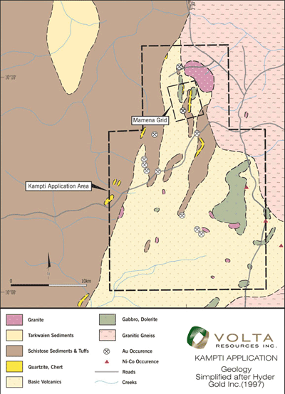 |
The Kampti property lies within the Houndé Greenstone Belt, one of a number of generally north-south Paleoproterozoic greenstone belts in western Burkina Faso. The Kampti III Permit is comprised of andesitic and dacitic volcanic and volcaniclastic rocks interbedded with fine-grained clastic and chemical (quartzite and chert) sediments (See Geology Map)). These supracrustal rocks have been intruded by mafic and granitic stocks. A diorite intrusion, about 8 km long and up to 2 km wide has intruded in the Maména-Fofora area, in the northernmost part of the permit. These rock units strike generally north-south and have steep dips.
A number of areas of mineralization have been identified within the Kampti III Permit. Most of the mineralization is present in high grade quartz vein structures. The main area of mineralization is located in the Maména-Fofora area where up until recently, it was estimated that over 15,000 artisanal miners were working. These artisanal miners are recovering gold from narrow quartz veins utilizing rudimentary techniques.
Two periods of veining are recognized in the Maména-Fofora area (Dr. I. Basson, 2007). An earlier vein set strikes at about 190º and dips westerly at 63º. These veins tend to cut the dominant foliation. Generally, these veins are not mined by the artisanal miners. Basson (2007) concluded that these veins were intruded prior to or during D1 deformation. Typically, these veins are unmineralized or too low grade to be of interest to artisanal miners.
The second set of veins strike at about 330º and dip steeply east. These veins are usually brecciated and contain vugs that may contain manganese oxide and/or sulphides. Basson (2007) considered that these brecciated veins were intruded during a period of extension and are considered to be contemporaneous with the intrusion of alkali leucogranite. These later veins are of interest to the artisanal miners; they are accompanied by kaolinization, sericitization, silicification and oxidation. The dominant host rocks for these mineralized veins are andesite and basalt.
The relation of narrow, high grade veins within a lower grade envelope appears to be reflected in the drilling results tabulated below.
Exploration Strategy
Stream Sediment Sampling
The initial program of work on the Kampti III Permit comprised a stream sediment sampling program (Bulk Leach Extractable Gold) over essentially all of the property. The results of this work outlined a north-south oriented central zone of higher values. The soil sampling program that followed targeted the corridor of higher values outlined by the stream sediment sampling.
Soil Sampling
A soil sampling program was completed in 2007 over the entire core area. Prior to commencing the soil sampling program, the Company completed an orientation survey to determine the best protocols for the planned work. Soil samples were collected on east-west lines with 200 m spacing. Sample stations were spaced at 100 m intervals. Samples were collected at depths of 0.5 m to 0.7 m. Individual sample sites/areas may not have been sampled because of the presence of areas of laterite cap or allochtonous/alluvial cover or because of significant ground disturbance, contamination and ongoing artisanal gold digging activity at the time of the soil sampling.
Subsequently, five areas were defined yielding significant anomalies. In-fill sampling was carried out on lies intermediate to the initial sampling. Stations were spaced at 50 m on the intermediate lines.
Trenching
To date the company completed five trenches within the Kampti III Permit; two of the trenches were dug in the southern part of the permit, at Kounkana-East, and aimed at testing respectively a copper and gold anomaly, while three trenches were dug in the northernmost Maména-Fofora part of the permit in order to test gold targets. Trenches were hand-dug typically to a depth of 2 m.
Trenching Results, Kampti III Permit
| Trench |
Length (m) |
Assay g/t Au |
| Fofora TR1 |
22 |
1.1 |
| 24 |
0.5 |
| 4 |
4.69 |
| 25 |
0.9 |
| Fofora TR2 |
32 |
0.6 |
| 34 |
2.3 |
Significant values were obtained in trenches TR1 and TR2 in Maména-Fofora, while a consistent and large copper anomaly, with values over 1,500ppm, were obtained in the trench at Kounkana-East.
Geophysics
An induced polarization (IP)/resistivity survey using a gradient array and (locally) a ground magnetic survey were carried out over the Maména-Fofora prospect in 2006.
The gradient array IP survey has identified a series of parallel NS to NNW trending chargeable horizons which are also very to moderately resistive. The anomalies are generally 50 metres or more wide and extend over several hundreds of meters in length, to both north and south beyond the reported artisanal gold workings.
The Mamena-Forfora Prospect
Drill Program
The Company has completed two programs of reverse circulation (RC) drilling on the Maména-Fofora prospect, located in the northern region of the Kampti III Permit. The first program was carried out in February, 2006, when ten holes, with an aggregate depth of 1,440 m were completed. The second stage of RC drilling was completed in November and December, 2006 when a further 16 holes were completed with an aggregate depth of 2,367 m. In all, 3,807 m of drilling was completed.
These holes were targeted to test geochemical and geophysical anomalies, and were also guided by the location of some of the artisanal workings in the area. Drilling was carried out by West African Drilling Services, a subsidiary of Layne Christensen Company of the United States of America.
Drilling intersected a series of meta-basalts and rhyolites with common quartz porphyry units. Alteration and mineralization are expressed by abundant narrow quartz veins, sulphides, ilicification and local kaolinisation. Gold mineralization seems to coincide with the abundant quartz veining inferred from the drill hole descriptions, which are described as locally very narrow. The results tend to confirm the presence of an abundant number of parallel, steeply dipping high grade mineralized veins and systems embedded in a lower grade envelope.
Mineralization appears to occur along chargeability zones (outlined by geophysics) and is particularly high where chargeability anomalies intersect NNE-SSW-trending secondary structures (Basson,2007).
Highlights of the drilling campaign are presented in the table hereunder :
RESULTS OF THE KAMPTI III DRILLING
| Hole No. |
From (m) |
To (m) |
Length (m) |
Assay g/t Au |
| RC1 |
44 |
48 |
4 |
1.29 |
| RC4 |
66 |
68 |
2 |
4.53 |
| RC5 |
102 |
104 |
2 |
37.9 |
| 122 |
140 |
18 |
0.98 |
| 126 |
138 |
12 |
1.32 |
| RC7 |
26 |
38 |
12 |
1.08 |
| RC8 |
64 |
66 |
2 |
6.96 |
| RC9 |
58 |
74 |
16 |
1.76 |
| 104 |
132 |
28 |
3.64 |
| RC10 |
6 |
10 |
4 |
3.70 |
| 58 |
60 |
2 |
15.8 |
| 124 |
130 |
6 |
1.81 |
| RC12 |
73 |
77 |
4 |
0.77 |
| RC13 |
147 |
149 |
2 |
1.17 |
| RC14 |
51 |
54 |
3 |
1.40 |
| RC15 |
97 |
102 |
5 |
1.18 |
| RC16 |
72 |
79 |
7 |
2.51 |
| RC17 |
31 |
42 |
11 |
1.11 |
| RC18 |
53 |
68 |
15 |
0.57 |
| RC19 |
73 |
81 |
8 |
2.23 |
| RC20 |
86 |
90 |
4 |
0.80 |
| RC21 |
78 |
81 |
3 |
63.52 |
| Incl. |
78 |
79 |
1 |
187.92 |
| RC22 |
17 |
18 |
1 |
13.25 |
| Incl. |
38 |
41 |
3 |
2.25 |
| 38 |
39 |
1 |
5.98 |
| RC23 |
24 |
31 |
7 |
0.82 |
| Incl. |
55 |
85 |
30 |
0.67 |
| 77 |
78 |
1 |
7.69 |
| RC24 |
63 |
64 |
1 |
3.55 |
Notes:
- The above intersections are based on a 0.2 g/t gold cut-off with no top cut applied. Internal dilution (less than 0.2 g/t gold) has been carried to a maximum of 4 m, except for RC 9 where a local internal dilution of 6 m at less than 0.2 g/t gold has been applied. The 0.2 g/t gold cut-off best expresses the lower-grade envelope in which the high-grade mineralized systems occur.
- Dry and wet samples were riffle-split and composited over 2 m intervals to provide 2 kg samples sent to the laboratory. Laboratory repeat assays were undertaken on an approximate basis of 1 in 10 samples. From a QA/QC perspective, the initial review of results suggests this is a satisfactory and reliable data set. Nevertheless certain of the analytical results are currently being re-evaluated as some minor inconsistencies were noted with the assaying of batches containing one particular reference standard. In such batches, assaying of this standard returned occasional values that varied from the expected value by 10-15%.
- Samples were sent to ALS-ABILAB Ouagadougou/Bamako for standard preparation then Fire Assay on 30g or 50g charge.
QA/QC
The Company maintains a QA/QC program in all of the sampling that it has undertaken. This program includes the use of reference samples, blanks and duplicates. Reference samples are included at a rate such that 5% of all samples sent for analysis; blanks are included at a rate of 3.3% of all samples and duplicate samples are included at a rate of 2%.
Next Steps
This year, the Company intends to carry out a new phase of drilling to test the Maména-Fofora target further, to be guided by recommendations made by a third part structural report carried out in late 2007. Other identified targets in the broader mineralized corridor, defined by the soil sampling and trenching program will be drilled. Approximately 3,000m will be drilled at Maména-Fofora and 2,000m on new targets.
|
|