|
|
|
Location and Background
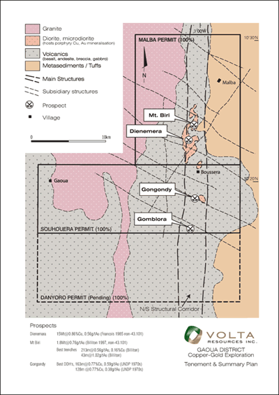
The Gaoua project covers 691.5 km² within the prolific Boromo greenstone belt, an early Proterozoic Birimian sequence of the West African Craton.
The project includes the 100%-owned, contiguous Malba, Souhouera and Danyoro permits, which hosts numerous copper-gold and gold prospects previously identified by historical aid programs. These permits cover about 35km in strike length of the prospective structural corridor that hosts most known copper-gold and gold occurrences. The three permits lie approximately 70 km northeast of Volta's Kampti permit.
Click to enlarge
 |
An expert review (by Dr. Richard Sillitoe) of the historical exploration data, along with core and data produced during current exploration efforts, confirm classic porphyry-style copper and gold mineralization.
An abundance of artisanal workings, extensive copper soil anomalies, coincident gold stream sediment anomalies, high magnetic susceptibility targets and induced polarization (IP) conductors suggest potential extensions of the current copper-gold mineralization. The Gaoua project make up a highly prospective porphyry copper-gold terrain that, until recently had not been explored using modern methods.
The region has established infrastructure including highways, plentiful water sources nearby, good power and telecommunication networks, and has historically been a major artisanal gold producing area of Burkina Faso.
Geology and Mineralization
The major geological units strike north-south. They include basaltic and andesitic rocks, together with volcanoclastic units and chemical sedimentary rocks (chert and quartzite). These units are intruded by diorite and dioritic breccia units.
Within the Malba and Souhouera Permits, there is a central structural corridor that hosts most known copper-gold and gold occurrences. Among those identified to date include the main prospects of Gongondy, Dienemera and Mt. Biri. These prospects contain mineralization hosted in various phases of the dioritic intrusive units.
The mineralization at all three of the drilled prospects is associated with a hydrothermal breccia that is largely hosted by diorite porphyry intrusions, though it locally extends into the adjacent volcanic tuffs and lavas. The Cu-Au mineralization is however usually confined to the dioritic porphyry dominated area. The mineralized breccia is characterized by small clasts and by the presence of centimetric clots of cementing minerals that approximate a triangular form. The hydrothermal cement is composed of quartz, K-feldspar, epidote, chalcopyrite, pyrite, calcite and anhydrite. Open cavities occur in core recovered from above the sulphate front, thereunder anhydrite is an important late cementing mineral. Most of the breccia-hosted mineralization consists of hypogene chalcopyrite with which gold values appear to be closely correlated.
Important isolated gold highs which are not immediately associated with the copper mineralization are frequently observed in the drill holes (see further). This gold mineralization appears to be related to mineralized veins which may post-date the Cu-Au sulphide mineralization phase.
Exploration Strategy
Stream Sediment and Soil Sampling
Stream geochemistry (Bulk Leach Extractable Gold) is used as an initial reconnaissance tool to outline potential areas of interest within the permits. A soil sampling program was used over the corridor of higher values outlined by the stream sediment sampling.
Soil sampling has already been carried out over the most prospective parts of the Malba, Souhouera and Danyoro permits to cover, and attempt to extend, the known mineralization. An area of about 49 km² has been tested. Samples were collected on east-west lines spaced at 200 m and samples were collected at stations spaced 25 to 50 m. The survey has outlined several anomalous areas that require follow-up. However, in places, the anomaly could be masked due to transported regolith including alluvium and duricrust.
Trenching
Trenching was completed at Dienemera and Mt. Biri. The purposes of the trenches were to allow better inspection and verification of soil anomalies. The trenches were dug by hand using local labour. Trenches were dug to a 2 metre depth where possible. All trenches confirmed the presence of highly anomalous copper values.
Geophysical Surveys
Sagax Afrique S.A. (Sagax) completed ground geophysical surveys over the prospects of Gongondy, Dienemera and Mt. Biri. A total of 22 line-kilometres of gradient array and 5.0 kilometres of dipole-dipole array IP, and 22 line-kilometres of ground magnetic data were acquired during the geophysical survey over the three targets.
The gradient array IP survey and four IP dipole-dipole test lines conducted over the Gongondy prospect identified one large principal, north-south trending, chargeable anomalous corridor with a maximum response of approximately 15 mV/V (milliseconds) above background. The corridor is affected by NNW and NNE trends, and is open to the north and south. Drilling of the chargeability anomalies (see further) showed that the anomaly is caused by the abundant presence of pyrite, possibly representing a halo around the Cu-Au core.
The gradient IP survey and dipole-dipole test lines at Dienemera identified a series of chargeable anomalies, roughly oriented north-south. The two main anomalies are broadly coincident with the copper-gold mineralization, as mapped from the drilling campaigns, although the IP anomalies extend beyond the drill-tested areas and remain open for further surveying. The main anomaly, which shows a maximum response of approximately 15 mV/V (milliseconds) above background, coincides with the area where, among others, drill hole DIE76 intersected 78m @ 0.56% Cu and 0.22g/t Au from surface, 11m @ 0.46% Cu and 0.19g/t Au from 184m; 13m @ 0.34% Cu and 0.12g/t Au from 218m and 4m @ 0.80% Cu and 0.72g/t Au from 265m depth.
Click to enlarge
 |
Click to enlarge
 |
Click to enlarge
 |
Click to enlarge
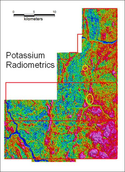 |
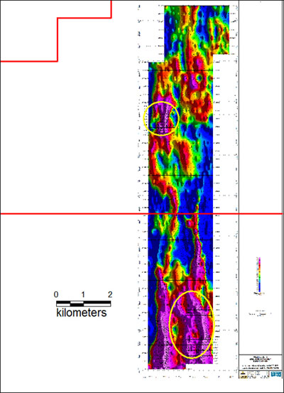
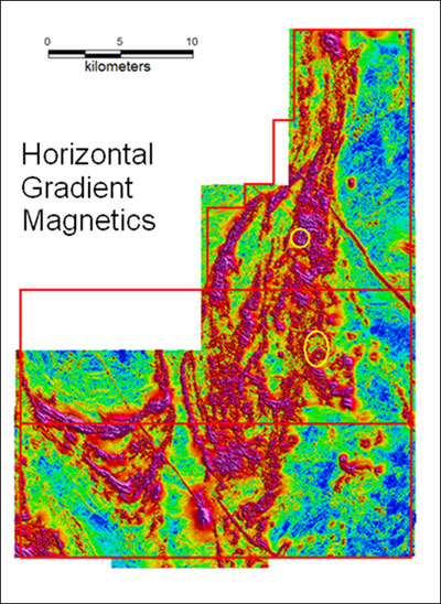
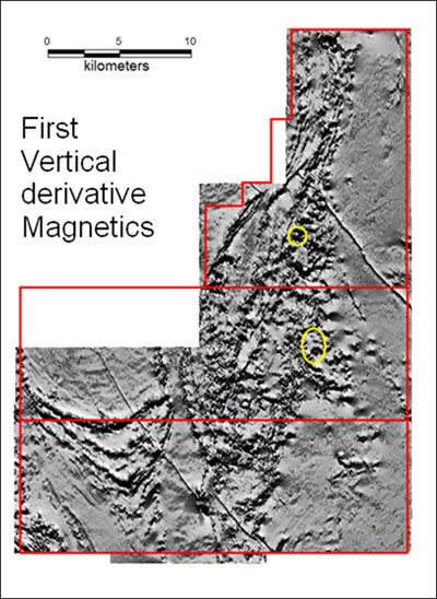
A high resolution, helicopter-borne geophysical survey covering most of the Gaoua properties was completed in late 2009. This includes both magnetic and radiometric data, which clearly highlight a coherent trend corresponding to the "porphyry corridor".
Drilling
To date, over 23,000 meters of drilling (mostly diamond drilling) has been completed by the Company at the Gaoua project. This drilling has tested several targets in three main areas: Gongondy, on the Souhouera property; and the Dienemera and Mont Biri targets, on the Malba property.
Copper-gold mineralization at Gongondy has been intersected for more than 2 km of strike length. Two mineralized centers are recognized along a north striking breccia body, (the "northern" and the "southern" blocks), separated by a post-mineralization intrusive gabbro body. The latest drilling indicates that the westward dipping gabbro is intrusive in the southern block. The mineralized envelope in the southern block clearly extends further west than previously thought and may connect to the northern block west of the gabbro. Copper and gold mineralization has now been defined by reverse circulation and diamond drilling in a J-shape around the gabbro in the southern block, significantly increasing the tonnage potential of the mineralized envelope at Gongondy.
At Dienemera, drilling has intersected copper-gold mineralization over the entire tested area, extending north-south for over 900m by nearly 850m at its widest point. In both areas, mineralization remains open in all directions. Further drilling will be needed to test whether the mineralization is continuous, hosted by one large body, or in a set of contiguous breccia bodies.
Drilling at Mont Biri, 2km north of Dienemera, intersected copper-gold mineralization in previously-untested areas, opening new targets for further exploration. Four diamond drill holes have been completed at Mt. Biri and significant mineralization was intersected in two of them. The intersections target different areas of potential mineralization. As the Mt. Biri drilling is at an early stage, it is not possible to discuss potential size of any mineralized body that may be developed by further drilling.
Salient intersections of the drilling campaign are presented in the tables hereunder. The shapes of the mineralized bodies have yet to be fully determined. True thicknesses of mineralization cannot be determined at present.
SIGNIFICANT DIAMOND DRILL INTERSECTIONS AT GONGONDY
Hole No. |
From (m) |
To (m) |
Length (m) |
Cu% |
Au g/t |
S23GON |
9 |
78 |
69 |
0.62 |
0.68 |
S26GON |
77 |
90 |
13 |
0.52 |
0.35 |
S27GON |
60 |
83 |
23 |
0.45 |
0.31 |
and |
119 |
178 |
59 |
0.61 |
0.36 |
Incl |
170 |
177 |
7 |
1.8 |
0.75 |
S32GON |
184 |
300 |
116 |
0.37 |
0.25 |
Incl |
277 |
300 |
23 |
0.79 |
0.45 |
S33GON |
20 |
46 |
26 |
0.75 |
1.11 |
and |
256 |
262 |
6 |
0.31 |
0.3 |
and |
282 |
288 |
6 |
0.37 |
0.3 |
S37GON |
1 |
41 |
40 |
<0.1 |
0.54 |
S38GON |
188 |
202 |
14 |
<0.1 |
1.16 |
Incl |
188 |
190 |
2 |
<0.1 |
5.27 |
S39GON |
0 |
8 |
8 |
0.43 |
0.26 |
and |
113 |
119 |
6 |
0.52 |
0.28 |
S40GON |
13 |
40 |
27 |
0.42 |
0.28 |
and |
183 |
197 |
14 |
0.33 |
0.29 |
and |
332 |
358 |
26 |
0.38 |
0.43 |
and |
378 |
391 |
13 |
0.31 |
0.27 |
S41GON |
411 |
420 |
9 |
0.31 |
0.34 |
S42GON |
136 |
156 |
20 |
0.36 |
0.37 |
S44GON |
86 |
110 |
24 |
0.41 |
0.42 |
and |
152 |
166 |
14 |
0.34 |
0.36 |
and |
259 |
388 |
129 |
0.5 |
0.52 |
incl |
259 |
300 |
41 |
0.43 |
0.52 |
incl |
311 |
388 |
77 |
0.6 |
0.56 |
S46GON |
151 |
168 |
17 |
0.3 |
0.37 |
and |
190 |
228 |
38 |
0.81 |
0.56 |
S47GON |
171 |
185 |
14 |
0.34 |
0.34 |
and |
237 |
255 |
18 |
0.3 |
0.26 |
S48GON |
260 |
326 |
66 |
0.39 |
0.41 |
S54GON |
128 |
154 |
26 |
0.36 |
0.33 |
and |
175 |
190 |
15 |
0.54 |
0.6 |
S56GON |
224 |
243 |
19 |
0.27 |
0.24 |
and |
267 |
322.5 |
55.5 |
0.79 |
0.56 |
incl |
284 |
310 |
26 |
1.27 |
0.84 |
S48GON |
89 |
116 |
27 |
0.39 |
1.71 |
and |
230 |
261 |
31 |
0.48 |
0.97 |
incl |
257 |
261 |
4 |
0.72 |
1.88 |
S50GON |
134 |
144 |
10 |
0.61 |
0.7 |
S52GON |
18 |
44 |
26 |
0.42 |
0.33 |
and |
210 |
222 |
12 |
0.39 |
0.71 |
and |
242 |
254 |
12 |
0.45 |
0.36 |
and |
338 |
349 |
11 |
0.72 |
0.94 |
and |
384 |
399 |
15 |
0.51 |
0.56 |
S55GON |
120 |
132 |
12 |
0.56 |
0.34 |
and |
166 |
180 |
14 |
0.42 |
0.3 |
S63GON |
10 |
134 |
124 |
0.56 |
0.34 |
incl |
33 |
45 |
12 |
1.18 |
0.81 |
S64GON |
28 |
38 |
10 |
0.38 |
0.32 |
and |
222 |
234 |
12 |
0.25 |
0.47 |
GRC2 |
21 |
28 |
7 |
0.26 |
0.42 |
GRC4 |
8 |
35 |
27 |
0.72 |
1.23 |
GRC5 |
49 |
55 |
6 |
0.28 |
0.3 |
and |
66 |
71 |
5 |
0.29 |
0.39 |
SIGNIFICANT DIAMOND DRILL INTERSECTIONS AT DIENEMERA
Hole No. |
From (m) |
To (m) |
Length (m) |
Cu% |
Au g/t |
S72DIE |
88 |
145 |
57 |
0.41 |
0.21 |
incl |
125 |
145 |
20 |
0.59 |
0.29 |
S73DIE |
147 |
162 |
15 |
0.48 |
0.15 |
S74DIE |
7 |
12 |
5 |
0.49 |
0.23 |
and |
38 |
49 |
11 |
0.46 |
0.14 |
and |
74 |
81 |
7 |
0.38 |
0.14 |
and |
158 |
191 |
33 |
0.37 |
0.13 |
and |
283 |
288 |
5 |
0.4 |
0.17 |
S75DIE |
44 |
90 |
46 |
0.33 |
0.1 |
and |
130 |
159 |
29 |
0.56 |
0.17 |
and |
182 |
197 |
15 |
0.61 |
0.25 |
S76DIE |
0 |
78 |
78 |
0.56 |
0.22 |
and |
184 |
195 |
11 |
0.46 |
0.19 |
and |
218 |
231 |
13 |
0.34 |
0.12 |
S77DIE |
2 |
11 |
9 |
0.43 |
0.14 |
and |
42 |
69 |
27 |
0.33 |
0.19 |
and |
127 |
162 |
35 |
0.44 |
0.27 |
S80DIE |
101 |
124 |
23 |
0.41 |
0.15 |
and |
211 |
230 |
19 |
1.28 |
0.24 |
S81DIE |
96 |
109 |
13 |
0.38 |
0.26 |
and |
129 |
149 |
20 |
0.4 |
0.21 |
S83DIE |
344 |
399 |
55 |
0.72 |
0.21 |
S84DIE |
173 |
180 |
7 |
0.49 |
0.13 |
and |
297 |
307 |
10 |
0.32 |
0.09 |
and |
324 |
393 |
69 |
0.59 |
0.21 |
S86DIE |
143 |
162 |
19 |
0.45 |
0.13 |
and |
168 |
186 |
18 |
0.34 |
0.1 |
and |
209 |
248 |
39 |
0.96 |
0.39 |
S87DIE |
197 |
234 |
37 |
0.41 |
0.12 |
and |
247 |
253 |
6 |
0.38 |
0.12 |
and |
280 |
293 |
13 |
0.41 |
0.16 |
S90DIE |
109 |
126 |
17 |
0.32 |
0.08 |
S93DIE |
74 |
157 |
83 |
0.43 |
0.24 |
S88DIE |
194 |
212 |
18 |
0.34 |
0.1 |
and |
308 |
444 |
136 |
0.41 |
0.14 |
incl |
308 |
341 |
33 |
0.64 |
0.19 |
S89DIE |
49 |
58 |
9 |
0.31 |
0.11 |
and |
195 |
218 |
23 |
0.5 |
0.21 |
S92DIE |
183 |
286 |
103 |
0.4 |
0.21 |
incl |
259 |
275 |
16 |
0.58 |
0.17 |
SIGNIFICANT DIAMOND DRILL INTERSECTIONS AT MT BIRI
Hole No. |
From (m) |
To (m) |
Length (m) |
Cu% |
Au g/t |
S45MBI |
117 |
130 |
13 |
1.53 |
1.07 |
and |
181 |
186 |
5 |
0.72 |
<0.1 |
S47MBI |
233 |
280 |
47 |
0.26 |
<0.1 |
incl |
256 |
262 |
6 |
0.39 |
<0.1 |
incl |
276 |
280 |
4 |
0.58 |
<0.1 |
All of the drilling was completed by West African Drilling Services, a subsidiary of Layne Christensen Company of the United States of America.
Resource Estimate
This drilling data has been used by independent consultants, SRK Consulting (UK) out of Cardiff, to define a NI 43-101 compliant Inferred Resource of 82,600,000 tonnes grading 0.40% copper and 0.40 g/t gold for a total of 724,880,000 lbs of copper and 1,072,900 ounces of gold, calculated at a 0.45% copper equivalent cut-off grade at Dienemera and Gongondy.
The resource is presented below at different CuEQ cut-off grades:
DEPOSIT |
Cut-off
Grade |
Tonnage |
Copper |
Gold |
Copper Equivalent |
>(CuEQ %) |
(tonnes) |
% |
lbs |
g/t |
Oz |
% |
lbs |
DIENEMERA |
0.60 |
9,200,000 |
0.64 |
129,632,000 |
0.25 |
74,600 |
0.79 |
160,276,000 |
|
0.50 |
18,100,000 |
0.54 |
214,510,000 |
0.22 |
128,600 |
0.67 |
267,421,000 |
|
0.45 |
23,000,000 |
0.50 |
255,075,000 |
0.21 |
155,300 |
0.63 |
319,009,000 |
|
0.40 |
27,800,000 |
0.47 |
372,802,000 |
0.20 |
237,700 |
0.59 |
364,424,000 |
|
0.30 |
41,700,000 |
0.41 |
372,802,000 |
0.18 |
237,700 |
0.51 |
470,687,000 |
|
0.20 |
57,400,000 |
0.35 |
440,704,000 |
0.15 |
284,700 |
0.44 |
557,769,000 |
GONGONDY |
0.60 |
27,200,000 |
0.43 |
257,279,000 |
0.62 |
541,300 |
0.80 |
479,946,000 |
|
0.50 |
45,800,000 |
0.38 |
387,793,000 |
0.52 |
768,200 |
0.70 |
703,936,000 |
|
0.45 |
59,600,000 |
0.36 |
469,805,000 |
0.48 |
917,600 |
0.65 |
847,236,000 |
|
0.40 |
78,300,000 |
0.33 |
568,793,000 |
0.44 |
1,102,200 |
0.59 |
1,022,283,000 |
|
0.30 |
125,900,000 |
0.28 |
766,547,000 |
0.37 |
1,506,400 |
0.50 |
1,386,266,000 |
|
0.20 |
170,400,000 |
0.24 |
893,974,000 |
0.33 |
1,793,000 |
0.43 |
1,631,641,000 |
TOTAL |
0.60 |
36,400,000 |
0.48 |
386,911,000 |
0.53 |
616,000 |
0.80 |
640,222,000 |
|
0.50 |
63,900,000 |
0.43 |
602,303,000 |
0.44 |
896,800 |
0.69 |
971,357,000 |
|
0.45 |
82,600,000 |
0.40 |
724,880,000 |
0.40 |
1,072,900 |
0.64 |
1,166,245,000 |
|
0.40 |
106,100,000 |
0.37 |
858,921,000 |
0.38 |
1,282,500 |
0.59 |
1,386,707,000 |
|
0.30 |
167,600,000 |
0.31 |
1,139,349,000 |
0.32 |
1,744,100 |
0.50 |
1,856,953,000 |
|
0.20 |
227,800,000 |
0.27 |
1,334,678,000 |
0.28 |
2,077,700 |
0.43 |
2,189,410,000 |
SRK constrained the resource in optimized open pits based on reasonable technical and economic parameters which they consider to have reasonable prospects for eventual economic extraction. The table above summarises the in-situ Mineral Resource stated at a 0.45% Copper Equivalent (CuEQ) cut-off grade within the defined mineralisation models. CuEQ has been calculated from assumed revenues of US$3,000/t copper and US$700/oz gold with metallurgical recovery assumed to be 85% and 70% respectively. Gold grade has been multiplied by 0.6 and added to the copper grade to provide a CuEQ grade. The cut-off grade further assumes typical costs of US$2/t for mining and US$10/t for processing and general administration costs.
Additional Potential
Click to enlarge
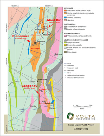 |
Geological mapping and soil geochemical surveying has identified several copper-gold anomalies in the 8km separating Gongondy and Dienemera/Mont Biri, considerably expanding the potential in the area.
Stream sediment sampling carried out over the southern part of the Souhouera and over the entire Danyoro properties has identified several copper and gold anomalies along strike with the known Cu-Au mineralization of Mt. Biri-Dienemera-Gongondy, extending the area for further testing by several kilometers to the south.
This copper and gold anomalism coincides with a geophysical trend clearly seen in both magnetic and radiometric data collected during the high resolution, heliborne survey completed in late 2009. The "porphyry corridor" trend extends for the full, length of all 3 properties.
Along this (southern) extension of the trend, approximately 5km south of Gongondy, occurs the gold artisanal site of Gomblora. More than 2,000 artisanal miners are currently exploiting gold from narrow quartz veins and altered host rocks. Gold is being mined from the abundant quartz veins and mineralized systems (shears) which occur essentially along the contact between basalts, gabbro and pyroclastics.
A sampling study aimed at determining the prospectivity of the Gomblora area has confirmed the widespread presence of high-grade gold mineralization. Out of the 71 collected grab samples 31 (43%) returned grades exceeding 1 g/t Au and 16 (22%) exceed 10 g/t Au. Most of the mineralized quartz vein material returned values above 1 g/t with peaks of 43, 67, 91 and 557 g/t Au respectively. The Gomblora gold mineralization is inferred to be related to the Cu-Au mineralizing system, possibly representing a higher level of the system.
Quality Control/Quality Assurance (QA/QC)
The Company maintains a QA/QC program in all of the sampling that it has undertaken. This program includes the use of reference samples, blanks and duplicates. Reference samples are included at a rate such that 5% of all samples sent for analysis are reference samples. Blanks are included at a rate of 3.3% of all samples and duplicate samples are included at a rate of 2%.
The company maintains close contact with the laboratory on matters regarding QA/QC.
Next Steps
The Company intends to carry out a paower auger drilling program between the Gongondy and Dienemerra deposits in order to identify potential copper-gold porphyry targets that may be masked by transported regolith material. Positive results will lead to further testing of identified targets by RC drilling.
An RC drilling program is also planned to extend the mineralization identified to the west of the post-mineral gabbro intrusive at Gongondy.
A 3D inversion exercise by an independent geophysical consultant is to be undertaken on the high resolution heli-borne magnetic survey data collected late in 2008 in order to fully utilize this information to understand the deeper structure of the "porphyry corridor".
|
|